What if the next big efficiency gain in renewable energy didn’t come from a new panel or turbine design, but from machines that already fly above them?
Picture a predawn sweep over a solar field: a thermal mosaic reveals a handful of overheating cells before sunrise, a compact quadcopter descends to remove dust from a string of panels, a long-endurance VTOL charts vegetation encroachment along a transmission corridor, each action cutting downtime, cost and risk. These are not future fantasies but the kinds of on-the-ground (and in-the-air) interventions changing how projects are built, maintained and scaled.
Curious which drone technologies are delivering the biggest wins today and how operators move from experimental pilots to measurable ROI? Below is a focused exploration of ten drone innovations that are already shifting the economics and engineering of renewable energy.
1. Autonomous Thermal Inspections
What it is: Regular thermal mapping with radiometric cameras to detect panel hotspots, inverter overheating, and faulty junctions. Flights are flown along fixed transects to produce orthomosaic thermograms.
Why it matters: Hotspots are predictive indicators of performance loss and fire risk in photovoltaic (PV) arrays and battery energy storage systems (BESS). Early detection reduces unplanned downtime and prevents catastrophic failures.
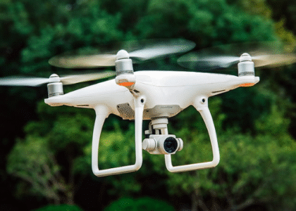
How it’s done: Multirotor drones equipped with radiometric thermal sensors (for enterprise use, Zenmuse-series sensors or Mavic/Phantom thermal variants) fly pre-planned grids at low altitude to capture thermal mosaics. Results are post-processed into geo-referenced thermal orthomosaics and per-module reports.
Real-world example: Research and field pilots (including autonomous fleet experiments documented in technical literature) show that thermal drone surveys can locate defective modules and string faults far faster than manual thermography, reducing inspection time for a 1 MW plant from days to a few hours.
Key tools: Radiometric thermal cameras, RTK-enabled GNSS for geolocation, automated flight planning (DJI Terra, DroneDeploy), and thermal analysis suites.
2. Drone-Based Cleaning & Maintenance for Solar Farms
What it is: Purpose-built drones with rotary brushes, suction heads or spray systems that remove dust and soiling from PV modules; experimental solutions also apply deionised-water misting or hydrophobic coatings.
Why it matters: Soiling can reduce yields by 5 to 30% depending on locale and season. Mechanical cleaning at scale using ground crews is water-intensive and slow; drone cleaning offers speed, access, and (in prototype cases) dramatic labor savings.
Real-world example: A 2025 startup in Nagpur demonstrated a drone-based cleaner capable of servicing a 1 MW plant in ~30 minutes, a significant reduction in time compared to manual crews and a promising method in water-stressed environments.
Key tools: Custom cleaning payloads, flight automation for precise pass coverage, safety interlocks to prevent damage to panels.
3. High-Precision Photogrammetry & RTK Mapping
What it is: Using photogrammetry from drones (often Phantom 4 RTK or Matrice with P1 camera) to create orthomosaics, digital surface models (DSMs) and high-resolution site maps for site selection, earthworks and volumetrics.
Why it matters: Accurate as-built models reduce survey time and cost, enable precise cut/fill and optimize cable routing and layout for large PV arrays and wind access roads.
How it’s done: RTK/PPK workflows (Phantom 4 RTK / Matrice with RTK modules) eliminate many ground control points and provide centimeter-level accuracy required for engineering inputs.
Key tools: DJI Phantom 4 RTK / Phantom 4 Pro (photogrammetry kits), Pix4Dmapper, DroneDeploy, and integration with CAD/Civil3D workflows.
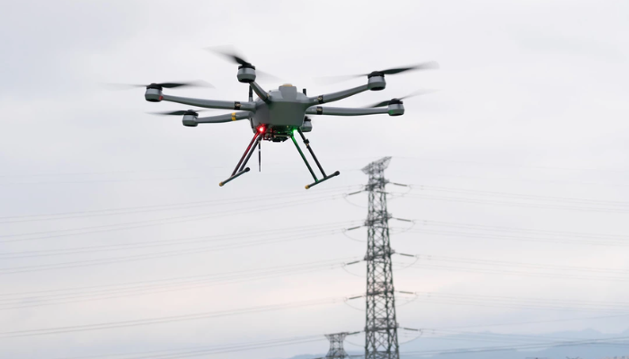
4. LiDAR for Vegetation & Corridor Management
What it is: LiDAR payloads mounted on Matrice-class platforms capture dense point clouds that reveal vegetation encroachment, slope stability, and small topographic variations under forest canopies.
Why it matters: For grid operators and wind developers, LiDAR flights reduce the need for line-crew boots on the ground, identify potential tree-strike risks and inform right-of-way maintenance programs.
Real-world use: LiDAR-fusion surveys help create reliable corridor models for high-voltage transmission line planning and maintenance, enabling predictive vegetation management that protects uptime.
Key tools: Matrice Series with Zenmuse L1 or RIEGL-mini LiDAR, point-cloud engines (LAStools, CloudCompare), and GIS integration.
5. Wind Turbine Blades & Tower Structural Inspection
What it is: High-resolution visual and thermal inspection of wind turbine blades, towers, and nacelles to identify cracks, delamination, lightning strike damage, and bearing temperatures.
Why it matters: Manual rope access is riskier and expensive. Drone inspections are faster, safer, and support automated defect detection pipelines.
How it’s done: Drones (Mavic 3 Enterprise with zoom/thermal) fly close passes along blade surfaces capturing oblique and nadir images. Operators feed imagery into AI models to detect surface anomalies.
Key tools: High-zoom cameras, thermal modules, AI image-classification models for automated defect tagging.
6. Persistent, Autonomous Fleet Surveys
What it is: Schedulers and autonomy stacks enabling fleets of drones to execute recurring inspections autonomously (BVLOS pilots are becoming feasible in controlled corridors).
Why it matters: For very large PV parks or linear infrastructure, a single drone sortie is insufficient. Fleet automation reduces per-MW inspection costs and enables near-continuous monitoring.
Research & practice: Autonomous path planning and persistent surveillance strategies are explored in academic work and pilot deployments; fleets can execute staggered flights for thermal/visual sweeps across multi-GW assets.
Key tools: Fleet management platforms (FlightHub / DroneDeploy Enterprise), automated mission planners, and (where regulation permits) BVLOS operations.
7. AI & Computer Vision for Predictive O&M
What it is: Applying machine learning to imagery and thermal datasets to detect patterns, predict failure modes and prioritize interventions.
Why it matters: Human inspection is subject to fatigue and inconsistency, AI models accelerate triage and help allocate maintenance scarce resources more effectively.
Use cases: Automated module anomaly detection, string-level performance prediction, blade surface classification, and hotspot clustering for BESS safety.
Key tools: Cloud ML pipelines, labeled training datasets, edge inference modules for onboard triage.
8. Environmental & Compliance Monitoring
What it is: Drones collect evidence for environmental impact assessments (EIA), monitor sediments near hydro projects, detect effluent leaks and map construction-phase disturbances.
Why it matters: Renewables development requires compliance with environmental norms; drones reduce inspection footprints and provide defensible, geo-tagged records for regulators.
Examples: Use in urban energy audits (e.g., heat-loss imaging for schools in Coventry) illustrates how aerial thermal mapping can support decarbonisation planning for building portfolios.
Key tools: Multispectral sensors, thermal cameras, e-nose prototypes for fugitive emissions, and EHS dashboards.
9. Precision Spraying & Micro-Logistics
What it is: Using small spray/payload drones for targeted pesticide, anti-soiling agents (experimental), or applying coatings in targeted areas.
Why it matters: Reduced chemical usage, targeted application to high-risk areas and minimal operator exposure to hazardous tasks.
Real-world pilots: Experimental sprays and micro-logistics (spare part drops) are being trialed in confined or remote sites; regulatory frameworks vary by jurisdiction.
Key tools: Spray payloads, precision dispensers, and fail-safe drop mechanisms.
10. Digital Twin Creation & Integration with Asset Management Systems
What it is: Converting repeated aerial datasets into time-series digital twins that feed CMMS/EAM (Computerized Maintenance Management Systems / Enterprise Asset Management).
Why it matters: Digital twins help operations teams visualize degradation over time, run predictive models and schedule allocated maintenance windows, improving uptime and lowering total cost of ownership.
Implementation: Integrate orthomosaics, LiDAR point clouds and sensor telemetry into asset management platforms (e.g., IBM Maximo, SAP EAM) for alerts and workflow automation.
Case Studies
Solar cleaning in Nagpur
In 2025 a Nagpur-based startup demonstrated a drone that cleaned 1 MW of panels in roughly 30 minutes. This prototype illustrates the operational potential of drone cleaning in water-scarce regions and the large time savings possible compared to manual teams.
Coventry schools energy audits (UK)
Municipal pilots in Coventry used drones for thermal audits of school buildings, identifying heat losses and prioritizing retrofits, a practical example of aerial data informing energy efficiency programs.
Platforms & why DJI family dominates the energy use-case mix
Industrial renewable workflows emphasize payload capacity, sensor compatibility and reliability. That’s why enterprise platforms are commonly deployed:
- DJI Matrice Series: High payload capacity, compatibility with LiDAR (Zenmuse L1), P1 photogrammetry cameras, H20T thermal/zoom payloads, ideal for LiDAR corridors, turbine inspection and heavy-duty grid tasks.
- DJI Phantom 4 RTK / Phantom 4 Pro: RTK photogrammetry workflows for mapping, site planning and accurate orthomosaics.
- DJI Mavic 3 Enterprise / Mavic 3T: A compact but capable option for rapid thermal/visual checks on rooftop PV and small O&M tasks where portability matters.
These platforms balance flight time, payload flexibility and enterprise-level software ecosystems (DJI Terra, FlightHub, third-party integrations), making them go-to choices in industry pilots and production work.
ROI & Economics
- Inspection time reduction: Thermal and photogrammetry inspections reduce site survey time by 70 to 90% relative to manual or rope access methods.
- Cost avoidance: Early identification of hotspot clusters reduces module replacements and loss of generation; wind blade inspections prevent unplanned turbine downtime.
- O&M efficiency: Automated tagging and prioritized maintenance can reduce truck rolls and crew deployments, yielding substantive operational savings over multi-year horizons.
Quantify benefits by running a pilot that measures time-per-inspection, mean time to repair (MTTR) before and after drone integration, and generation uplift from reduced soiling.
Best Practices & Risk Management
- Sensor calibration: Calibrate PMs/thermal sensors against ground references to ensure radiometric accuracy and defensible reports.
- Flight safety: Use redundant observers for over-people flights, geofencing, and ensure third-party insurance for commercial operations.
- Data governance: Establish retention policies, anonymize sensitive imagery, and integrate secure cloud storage with access controls.
- Vendor selection: Buy from authorized distributors (for DJI platforms this ensures warranty & spares availability) and vet data-processing vendors for SOC2 or equivalent security posture.
Conclusion
Drones are not an add-on, they are an operational instrument for renewable energy projects. To extract full value you need three capabilities in lockstep: the right hardware, proven mission workflows, and trained personnel who can interpret data into maintenance action.
FlyandTech provides authorized enterprise hardware (including DJI Matrice Series and Mavic 3 Enterprise/T variants), Drone Pilot training program aligned to local aviation rules, and mission-planning support that shortens ramp-up time. Follow us for operational case studies, demo flights and training schedules.
FAQs
1. What are the top drone use cases in renewable energy?
Thermal inspections, automated photogrammetry/RTK mapping, LiDAR corridor surveys, turbine blade inspections, drone cleaning, autonomous fleet monitoring, AI-driven predictive maintenance, environmental compliance monitoring, precision spraying, and digital-twin creation.
2. Which drone platforms are best suited for utility-scale renewable projects?
Enterprise platforms such as the DJI Matrice Series (for LiDAR and heavy payloads), DJI Phantom 4 RTK (for photogrammetry) and DJI Mavic 3 Enterprise / Mavic 3T (for thermal rooftop and rapid inspections) are commonly used.
3. Can drones replace manual inspections entirely?
Drones significantly reduce manual inspection frequency and scope but do not fully replace on-site repair crews, they enable predictive maintenance and more targeted, less frequent manual interventions.
4. How should a renewable operator start a drone program?
Begin with a focused pilot: choose a representative asset, define KPIs, run thermal and photogrammetry surveys with an experienced operator, validate data accuracy, then scale workflows with fleet/software integration.
5. Are there regulatory limits to drone cleaning or spraying operations?
Yes, spraying and chemical payloads are tightly regulated in many jurisdictions. Operators must secure specific approvals and meet environmental and aviation safety requirements before deploying spray payloads.