In today’s high-stakes operational environments, extending both flight time and drone camera range has become a critical performance metric. From surveying vast agricultural lands to inspecting critical infrastructure, long range drones are proving indispensable for professionals
Initially, drones were confined to military or niche surveillance applications. Over the past decade, breakthroughs in battery technology, aerodynamic design, and advanced telemetry have revolutionized long-range drone capabilities.
Today’s models incorporate features that extend flight ranges up to 200 kilometers, making these long range drones stand out. They support sophisticated imaging systems for enhanced drone camera range, delivering high-quality aerial imagery. The market is witnessing a surge in demand as industries require reliable long range drone solutions that offer extended flight capabilities and superior imaging performance.
Key Technological Advancements:
- Battery and Power Management: Innovations like high-density lithium-polymer and emerging solid-state batteries extend flight times dramatically. For example, the JOUAV CW-30E offers up to 480 minutes of flight time.
- Aerodynamic Efficiency: The use of carbon fiber composites and optimized wing designs in fixed-wing models, such as those offered by JOUAV, minimizes drag and maximizes endurance.
- Advanced Telemetry: Dual-frequency systems (1.4GHz, 2.4GHz, and 5.8GHz) and integrated GPS/GLONASS modules ensure stable connectivity and precise positioning, even at extended distances.
Top Long-Range Drones
- Fixed-Wing Titans
Fixed-wing drones generally excel in achieving extended ranges, thanks to their aerodynamic design and energy-efficient flight mechanics. Here, we detail two standout models:
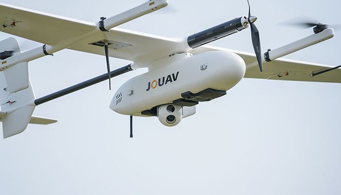
- JOUAV CW-30E

Specifications:
- Maximum Range: 200 km (124 miles)
- Flight Time: Up to 480 minutes
- Payload Capacity: 8 kg
- Transmission Band: 1.4 GHz for reduced interference
- Safety Features: Obstacle avoidance radar, ADS-B, auto-return, and advanced RTK/PPK positioning
Overview:
The CW-30E is engineered for professionals who demand exceptional range and reliability. Its robust construction, combined with a versatile payload capacity, makes it ideal for tasks such as mapping large areas or inspecting remote infrastructure. The drone’s integrated dual-optical gimbal system and high-zoom capabilities enhance its drone camera range, ensuring detailed imagery from high altitudes.
2. Quantum Trinity Pro

Specifications:
- Maximum Range: Up to 100 km (62 miles)
- Flight Time: Approximately 90 minutes (in standard configuration)
- Payloads: Dual RGB & NDVI cameras with 42MP high-resolution imaging
- Key Features: PPK integration, live air traffic monitoring via ADS-B, and advanced flight planning with QBase 3D software
Overview:
Targeted at professionals in surveying and agriculture, the Trinity Pro excels in providing detailed aerial data through its advanced imaging payloads. Its sophisticated terrain tracking and LiDAR-assisted flight controls ensure stable performance, even in challenging conditions. While some interference may be experienced on the 2.4 GHz frequency band, its overall design prioritizes precision and robust data collection.
B. Multirotor Marvels
Multirotor drones, known for their maneuverability and ease of deployment, have also seen significant improvements in range and imaging quality.
3. Parrot Anafi AI

Specifications:
- Maximum Range: 23 km (14 miles)
- Camera System: 48 MP sensor, 4K HDR video capability, and 6-axis hybrid image stabilization
- Connectivity: First drone with encrypted 4G data link for enhanced control
- Unique Feature: AI-powered automated flight planning
Overview:
The Anafi AI stands out with its innovative use of 4G connectivity, allowing for a more reliable connection beyond typical line-of-sight limitations. Its camera system is optimized for both stills and video, offering exceptional clarity in a variety of lighting conditions. Despite a slightly shorter flight time compared to fixed-wing drones, its rapid deployment and ease of use make it a popular choice for professionals in urban environments.
4. DJI Matrice 350 RTK

Specifications:
- Maximum Range: 20 km (12 miles)
- Flight Time: Up to 55 minutes
- Payload Capacity: Up to 2.7 kg, compatible with the Zenmuse H20 sensor suite
- Transmission System: DJI O3 Enterprise for robust HD live streaming
- Additional Features: 6-way binocular vision, integrated RTK system, and multiple satellite navigation options
Overview:
The Matrice 350 RTK is engineered for precision tasks like surveying and industrial inspections. Its robust transmission system and advanced obstacle avoidance sensors ensure safety and stability during extended missions. Despite premium pricing, the drone’s capabilities in delivering high-quality, real-time data make it a valuable asset for professionals requiring detailed aerial assessments.
C. Versatile Systems for Diverse Needs
5. DJI Air 3

Specifications:
- Maximum Range: 20 km (12 miles)
- Flight Time: Up to 46 minutes (in optimal conditions)
- Key Features: OcuSync O4 transmission technology, dual-camera system (12 MP and 48 MP sensors), and comprehensive intelligent flight modes
- Design: Compact and portable with effective obstacle avoidance
Overview:
The DJI Air 3 is designed for professionals who need a balance between portability and performance. Its dual-camera setup provides a mix of high-resolution imaging and telephoto capabilities, ensuring that even at extended ranges, the drone camera range remains uncompromised. This model is particularly popular among creative professionals and field inspectors, thanks to its ease of use and competitive pricing.
6. DJI Mavic 3 Pro

Specifications:
- Maximum Range: 15 km (9 miles)
- Flight Time: Up to 43 minutes
- Camera System: Triple-camera array including a 20 MP Hasselblad sensor, a 48 MP mid-range camera, and a 12 MP zoom lens
- Transmission: OcuSync 3.0 for enhanced signal stability
Overview:
The Mavic 3 Pro combines cutting-edge camera technology with reliable long-range performance. With its triple-camera system, this drone is ideally suited for detailed aerial photography, industrial inspections, and creative cinematography. It also features comprehensive obstacle sensing, ensuring safe operation in diverse environments.
7.Autel EVO II Pro V3

Specifications:
- Maximum Range: 15 km (9 miles)
- Camera System: 6K video capabilities, 20 MP RAW imaging with a 1-inch sensor
- Flight Features: Extensive pro camera controls and automated flight paths
- Design: Durable construction with premium accessories for rugged environments
Overview:
Autel’s EVO II Pro V3 is recognized for its impressive imaging quality and robust build. Though its battery life may slightly limit long-range flights, its overall performance in delivering professional-grade images makes it a strong contender in the long-range multirotor category.
Long-Range Drones Specifications Chart
| Model | Company | Max Range | Flight Time | Payload Capacity | Transmission | Camera Specs |
| JOUAV CW-30E | JOUAV | 200 km (124 miles) | Up to 480 min (8 hrs) | 8 kg | 1.4 GHz band | Dual-optical gimbal with up to 30x zoom |
| Quantum Trinity Pro | Quantum Systems | 100 km (62 miles) | ~90 min | Advanced sensor payload | 2.4 GHz telemetry / QBase 3D | 42MP high-res RGB & NDVI camera |
| Parrot Anafi AI | Parrot | 23 km (14 miles) | 32 min | – | Encrypted 4G connectivity | 48MP sensor; 4K HDR video |
| DJI Matrice 350 RTK | DJI | 20 km (12 miles) | 55 min | Up to 2.7 kg | DJI O3 Enterprise (1080p live) | Zenmuse H20 camera system (20MP zoom, etc.) |
| DJI Air 3 | DJI | 20 km (12 miles) | 46 min | – | DJI O4 transmission system | Dual 48MP cameras (wide-angle & 70mm telephoto) |
| DJI Mavic 3 Pro | DJI | 15 km (9 miles) | 43 min | – | DJI OcuSync 3.0 | Triple-camera array (20MP Hasselblad, 48MP mid, 12MP zoom) |
| Autel Evo II Pro V3 | Autel Robotics | 15 km (9.3 miles) | 40 min | – | Dual-band, frequency-hopping | 20MP sensor; 6K video at 30fps |
Understanding the Critical Metrics: Flight Range and Camera Range
Flight Range
Flight range refers to the maximum distance a drone can travel on a single battery charge. This metric is influenced by:
- Battery Capacity and Weight: More energy-dense batteries provide extended flight time but also add weight, affecting overall performance.
- Aerodynamic Design: Streamlined and lightweight materials reduce energy consumption, enabling drones like the CW-30E to achieve ranges of up to 200 km.
- Environmental Conditions: Wind, altitude, and payload weight can significantly affect the effective range.
The Importance of Drone Camera Range
While flight range determines the drone’s operational reach, drone camera range determines the quality of the imagery collected. Key factors include:
- Sensor Quality: High-resolution sensors (e.g., the 48 MP sensor on the Parrot Anafi AI) capture detailed images from afar.
- Stabilization Technology: Gimbals and hybrid image stabilization systems maintain focus and clarity even in adverse conditions.
- Transmission Stability: Robust communication systems, like those in DJI models, ensure a steady video feed over long distances, critical for real-time operations.
By integrating both flight and camera range metrics, professionals can ensure their aerial systems provide accurate, high-resolution data from remote or hard-to-reach areas.
Real-World Applications and Industry Impact
Aerial Surveying and Mapping
High-range drones such as the JOUAV CW-30E and Quantum Trinity Pro have transformed aerial surveying. Their extended flight times and advanced imaging systems allow for:
- Comprehensive Land Mapping: Accurate topographical mapping of vast areas using high-resolution cameras and RTK/PPK technology.
- Precision Agriculture: Detailed imaging for crop health monitoring and resource management, minimizing the need for ground inspections.
- Infrastructure Inspection: Efficiently surveying power lines, pipelines, and bridges with high-definition, long-range imaging systems.
Environmental Monitoring and Conservation
Long-range drones are pivotal in conservation efforts:
- Wildlife Monitoring: Capturing detailed images and videos over large territories with minimal disturbance.
- Forest Health Assessment: Detecting early signs of wildfires or disease with thermal imaging and high-resolution cameras.
- Climate Research: Collecting data on environmental changes across extensive areas for scientific analysis.
Industrial and Emergency Response Applications
For industries like energy and construction, long-range drones offer:
- Cost-Effective Inspections: Regular aerial checks reduce the need for hazardous manual inspections.
- Rapid Disaster Response: Drones like the DJI Matrice 350 RTK and Autel EVO II Pro V3 deliver real-time data during emergencies, enabling faster decision-making.
- Enhanced Safety Protocols: Integrated obstacle detection and advanced telemetry ensure safe operation in high-risk environments.
Future Trends and Innovations
AI and Autonomous Flight
The integration of artificial intelligence is set to revolutionize drone operations:
- Dynamic Flight Path Optimization: AI algorithms analyze real-time data to adjust routes and maximize both flight and drone camera range.
- Predictive Maintenance: Machine learning helps predict potential system failures, reducing downtime.
5G and Enhanced Connectivity
With the rollout of 5G networks:
- Increased Data Transmission: Lower latency and higher bandwidth enable stable, real-time HD video streaming.
- Extended Operational Ranges: Enhanced connectivity supports remote operation even in challenging environments.
Sustainable Energy Solutions
Innovation is also focused on sustainability:
- Solar-Powered Enhancements: Future drones may integrate solar panels to extend flight time during daylight operations.
- Eco-Friendly Materials: Ongoing research into sustainable, lightweight composites may further improve efficiency.
Innovations Showcased at Drone Conference 2025
At the recent Drone Conference 2025, industry leaders unveiled several groundbreaking innovations in long-range drone technology. Companies such as DJI, Autel Robotics, JOUAV, Quantum Systems, and Parrot demonstrated how advanced transmission systems, AI-driven autonomy, and sustainable energy solutions are pushing the boundaries of what drones can do. For example:
- DJI presented its latest Air 3 and Mavic 3 Pro, featuring the new O4 and OcuSync 3.0 transmission systems for extended range and robust, high-definition live feeds.
- Autel Robotics showcased its Evo series – Evo II Pro V3, Evo Lite Plus, and Evo Nano Plus, which utilize dual-band transmission technology and upgraded sensors to achieve impressive ranges and professional-grade imaging.
- JOUAV demonstrated the CW-30E and CW-15, highlighting cutting-edge payload capacity and endurance, while Quantum Systems introduced its Trinity Pro model, emphasizing its advanced terrain tracking and high-resolution payloads.
- Parrot emphasized the benefits of 4G-encrypted connectivity with its Anafi AI, ensuring secure control and high-quality imaging even in congested urban environments.
- Additionally, Helsing (a European AI specialist) showcased its HX-2 attack drone – an innovation designed to provide a counter-invasion shield with autonomous target engagement.
How Fly and Tech Can Empower Your Drone Journey
As long-range drone technology continues to evolve, partnering with Fly and Tech provides you with:
- A Curated Selection: Access to state-of-the-art drones like the DJI’s latest models.
- Comprehensive Training: Expert-led sessions to ensure optimal usage and maintenance.
- Technical Support: Ongoing guidance to maximize the potential of your aerial systems.
- Seamless Purchasing Experience: An intuitive online platform to compare, select, and acquire the right drone solution for your specific needs.